
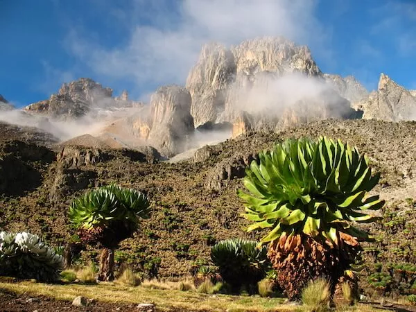

Kenya, situated between latitudes $6^{\circ}N$ and $6^{\circ}S$, represents a complex intersection of tectonic activity, equatorial climatic variability, and strategic maritime positioning. Spanning approximately 580,367 square kilometers, the nation is geographically defined by its 1,586-kilometer coastline along the Indian Ocean and its dramatic interior, which rises from coastal plains to the massive fracture of the Great Rift Valley and the glaciated peaks of the central highlands. This territory is more than a physical landscape; it is a foundational resource base that dictates the nation’s economic potential, with roughly 80% to 88% of the land classified as Arid and Semi-Arid Lands (ASALs), while only a modest 17% of the land is considered arable. The interplay between these diverse geographical zones creates a unique socio-economic environment characterized by high climate variability, concentrated agricultural productivity in the highlands, and a burgeoning energy sector leveraging the geothermal heat of the Rift.
- Tectonic Foundations and Geomorphological Framework
- Climatological Variability and Meteorological Patterns
- Hydrological Systems and Drainage Basins
- Ecosystems and Bioregional Distribution
- Administrative Geography: The 47 Counties and Devolution
- Urban Geography and Strategic Nodes
- Natural Resources and Energy Geography
- Geopolitical Geography and Border Disputes
- Environmental Risks and Future Outlook
Tectonic Foundations and Geomorphological Framework
The physical structure of Kenya is the result of millions of years of rifting and volcanic activity associated with the East African Rift System. The 38th meridian serves as a vertical divider, splitting the country into two strikingly different halves: an eastern portion that slopes gently toward the Indian Ocean and a western portion that rises abruptly through hills and plateaus to the Eastern Rift Valley.
The Great Rift Valley and Volcanic Architecture
The Great Rift Valley, a 5,000-kilometer fracture extending from the Levant to Southern Africa, bisects Kenya into eastern and western highlands. This tectonic trench varies in width from 30 to 80 miles (50 to 130 km) and features a floor that rises and falls dramatically. At its highest point near Lake Naivasha, the valley floor sits at approximately 2,100 meters, while it descends to roughly 450 meters in the arid northern basin of Lake Turkana and 600 meters at the Tanzanian border.
The volcanic history of this region has created massive freestanding cones. Mount Kenya, an extinct volcano, is the highest point at 5,199 meters, featuring glaciated peaks like Batian and Nelion. Mount Elgon, on the Ugandan border, rises to 4,321 meters and is another significant relic of the region’s volcanic past. The Rift floor is further studded with smaller volcanic features such as the Menengai Crater, Mount Longonot, and the Suswa volcano, many of which still exhibit geothermal activity.
The Plateaus and Coastal Forelands
Moving away from the Rift, the land transitions into expansive plateaus and low-lying plains. The Yatta Plateau, a remarkably flat feature flanked by the Machakos and Mbooni Hills, stretches for hundreds of kilometers, while the Uasin Gishu Plateau in the west provides high-altitude terrain suitable for large-scale wheat and maize farming. The Eastern Plateau, ranging from 300 to 900 meters in altitude, is punctuated by residual hills like the Taita and Chyulu Hills, which break the monotony of the semi-arid bushland.
The coastal plain is a narrow strip, approximately 10 miles wide in the south, which widens to nearly 100 miles in the Tana River lowlands. Underpinned by Jurassic and Karoo System sediments, this region features coral reefs, mangrove swamps, and several river deltas that provide critical ecological services.
| Physical Feature | Maximum Elevation (m) | Geological System | Primary Land Use |
| Mount Kenya | 5,199 | Quaternary Volcanics | Conservation/Water Tower |
| Mount Elgon | 4,321 | Tertiary Volcanics | Agriculture/Forestry |
| Aberdare Range | ~4,000 | Tectonic/Volcanic | Water Catchment |
| Mau Escarpment | ~3,000 | Volcanic Block | Primary Water Tower |
| Yatta Plateau | ~1,100 | Phonolite Lava Flow | Ranching/Conservation |
| Taita Hills | 2,134 | Precambrian Basement | Small-scale farming |
Climatological Variability and Meteorological Patterns
Kenya’s climate is not uniform; it varies from the hot, humid tropical conditions of the coast to the temperate highlands and the hyper-arid deserts of the north. This diversity is primarily governed by altitude and the migration of the Inter-Tropical Convergence Zone (ITCZ).
The Seasonal Cycle and the ITCZ
The ITCZ, a belt of low pressure near the Equator, drives the “long rains” from March to May and the “short rains” from October to December. During these periods, rainfall can exceed 300mm per month in high-altitude regions, while the intervening dry seasons are characterized by high evaporation rates. The onset and reliability of these rains are increasingly uncertain due to climate change, posing risks to the rural poor who depend on rain-fed agriculture.
Altitudinal Temperature Gradients
Temperature is largely a function of elevation. For every 1,000 meters of ascent, the average temperature drops significantly. Coastal cities like Mombasa maintain average temperatures around $29^{\circ}C$, while high-altitude cities like Nairobi ($1,798\text{ m}$) range from $9^{\circ}C$ to $27^{\circ}C$. In the alpine zones of Mount Kenya, temperatures can drop below freezing, while the northern deserts experience extreme diurnal swings.
The theoretical temperature $T$ at an altitude $h$ can be modeled using the standard environmental lapse rate:
$$T_{h} = T_{sea} – \left( 0.0065 \times h \right)$$
This formula underscores why the Kenyan highlands, despite being on the Equator, offer a temperate climate that attracted colonial settlement and continues to support the nation’s most successful agricultural enterprises.
Hydrological Systems and Drainage Basins
The hydrology of Kenya is dominated by five main drainage basins: Lake Victoria, Rift Valley, Athi River, Tana River, and Ewaso Ng’iro. An estimated 75% of surface water originates from the “five water towers”: the Mau Forest Complex, Mount Kenya, the Aberdare Range, Mount Elgon, and the Cherangani Hills.
Major River Networks
The Tana River is the longest in Kenya, flowing 1,050 kilometers from the Aberdares and Mount Kenya to the Indian Ocean. It supplies 19% of the country’s freshwater and powers five major dams that produce 60% of Kenya’s hydroelectricity. However, the damming of the Tana has reduced sediment loads to the Tana River Delta, a Ramsar site essential for biodiversity and local livelihoods.
The Athi-Galana-Sabaki River system drains the southern highlands and Nairobi area, flowing through the semi-arid eastern plains to the Indian Ocean. This basin, while critical, suffers from significant heavy metal and bacteriological pollution due to its proximity to the capital. In the north, the Ewaso Ng’iro River drains 36% of Kenya’s land area but provides only 2% of its surface water, making it a region of high groundwater dependence.
The Lake Systems
Kenya possesses a variety of lakes, from the freshwater giants to alkaline desert pools. Lake Victoria, shared with Uganda and Tanzania, is the most productive freshwater body, accounting for 59% of Kenya’s surface water. In the Rift Valley, Lake Turkana—the world’s largest permanent desert lake—stands as an endorheic basin with high salinity and no outlet.
The Rift Valley also hosts a chain of alkaline lakes (Bogoria, Nakuru, Elementaita) that support unique trophic dynamics, particularly the growth of Spirulina platensis algae, which feeds massive populations of lesser flamingos.
| Lake Name | Type | Surface Area (km2) | Primary Basin | Notable Issue |
| Turkana | Alkaline/Saline | 6,405 | Rift Valley | Salinity/Isolation |
| Victoria | Freshwater | 3,855 | Lake Victoria | Eutrophication/Overfishing |
| Naivasha | Freshwater | 149 | Rift Valley | Over-abstraction/Water levels |
| Baringo | Freshwater | 155 | Rift Valley | Siltation/Flooding |
| Magadi | Hyper-saline | 110 | Rift Valley | Commercial soda ash mining |
| Bogoria | Alkaline | 40 | Rift Valley | Geothermal activity |
| Elementaita | Alkaline | 21 | Rift Valley | Pelican breeding site |
Ecosystems and Bioregional Distribution
Kenya’s ecosystems are as varied as its topography, categorized into forests, savannahs, ASALs, and marine zones.
Savannahs and Arid Lands
Grasslands and savannahs cover 60% to 70% of the land area, predominantly in the ASALs of the north and east. These regions, including the Maasai Mara and Tsavo, are the heart of Kenya’s tourism industry, supporting iconic megafauna. However, these lands are increasingly degraded by overgrazing and climate-induced droughts.
Forests and Water Towers
Forest cover currently stands at approximately 7.8% (4.5 million hectares), with indigenous closed-canopy forests representing only 2% of the land. The “five water towers” are critical for regulating the country’s water supply, yet they face persistent threats from illegal logging, charcoal burning, and encroachment for settlement. Biomass still accounts for 78% of the energy consumed in Kenya, placing immense pressure on these wooded areas.
Marine and Mangrove Ecosystems
Kenya’s 640-kilometer coastline is home to 61,271 hectares of mangroves, primarily in Lamu County. These forests are vital carbon sinks, sequestering up to 15% of total carbon in the coastal ocean. They also provide shoreline protection and nursery grounds for fisheries. Coral reefs, covering 630 $km^2$, further enhance marine biodiversity but are sensitive to rising sea temperatures and sedimentation from river runoff.
Administrative Geography: The 47 Counties and Devolution
The 2010 Constitution introduced a devolved system of government consisting of one national government and 47 county governments. This restructure aimed to address historical regional inequalities where investment had been concentrated in the “high-potential” highlands while marginalizing the arid north and east.
Demographic and Geographic Divergence
The counties vary significantly in land area and population density. Marsabit is the largest county by land area ($70,944\text{ km}^2$), while Mombasa is the smallest ($220\text{ km}^2$). Population distribution is heavily skewed toward the highlands and Lake Victoria basin, with Nairobi County hosting over 4.3 million people in a mere $695\text{ km}^2$.
| County Code | County Name | Capital | Area (km2) | 2019 Population |
| 001 | Mombasa | Mombasa | 212.5 | 1,208,333 |
| 004 | Tana River | Hola | 35,375.8 | 315,943 |
| 010 | Marsabit | Marsabit | 66,923.1 | 459,785 |
| 023 | Turkana | Lodwar | 98,597.8 | 1,504,976 |
| 032 | Nakuru | Nakuru | 7,509.5 | 2,162,202 |
| 037 | Kakamega | Kakamega | 3,033.8 | 1,867,579 |
| 047 | Nairobi | Nairobi | 694.9 | 4,397,073 |
Fiscal Devolution and the Equalization Fund
Under the current framework, 84.5% of national revenue is allocated to the national government, while 15% is shared among the counties. A dedicated “Equalization Fund” of 0.5% is directed toward marginalized areas to bring basic services like health, water, and roads up to the level of the rest of the country. This fiscal geography is designed to stimulate growth in formerly neglected regions, such as Turkana and the northern frontier.
Urban Geography and Strategic Nodes
Kenya’s urban landscape is dominated by three primary cities, with secondary cities like Nakuru and Eldoret playing increasingly vital regional roles.
Nairobi, Mombasa, and Kisumu
Nairobi, the capital, is a regional commercial hub and the only major city globally to host a national park within its borders. Mombasa remains the country’s chief port, serving landlocked neighbors and facilitating international trade. Kisumu, situated on Lake Victoria, serves as the principal inland port, connecting Kenya to the greater Lake Victoria basin and the markets of Uganda and Tanzania.
Eldoret and Nakuru: Emerging Economic Blocks
Eldoret, located on the Uasin Gishu Plateau, is the headquarters of the North Rift Economic Bloc (NOREB) and a major center for wheat and maize processing. Nakuru, recently elevated to city status, is a critical convergence point for national transport and a leading agricultural hub in the Rift Valley. Nakuru’s GDP per capita of $1,413$ is the fourth highest in Kenya, reflecting its strategic importance as a link between the capital and the western regions.
Natural Resources and Energy Geography
Kenya is richly endowed with mineral and renewable energy resources, which are central to its “Vision 2030” development plan.
Geothermal and Renewable Potential
Kenya is a world leader in geothermal energy, utilizing the volcanic heat of the Rift Valley. Geothermal potential in the Rift is estimated at 7,000 to 10,000 MW, with current production centered at Olkaria and Menengai. The country also hosts the largest wind farm in Africa (310 MW) in Turkana County, taking advantage of the unique wind funneling effects between northern mountains.
Minerals and Hydrocarbons
Significant discoveries of oil in the South Lokichar Basin of Turkana and natural gas in Lamu have shifted Kenya’s extractive landscape. Other strategic minerals include titanium in Kwale, soda ash in Lake Magadi, and gold in the Migori and Kakamega regions. Rare Earth Elements (REE) and Niobium at Mrima Hills represent some of the most valuable undeveloped resources in the world, with an estimated in-ground value of billions of dollars.
Geopolitical Geography and Border Disputes
Kenya shares boundaries with Tanzania, Uganda, South Sudan, Ethiopia, and Somalia. These borders are often the site of resource-based conflicts and diplomatic maneuvering.
Maritime Claims
Kenya maintains a territorial sea of 12 nautical miles and an Exclusive Economic Zone (EEZ) of 200 nautical miles, covering approximately 116,942 $km^2$. These waters are essential for the blue economy, including fisheries and potential offshore hydrocarbon exploration.
The Ilemi Triangle
A long-standing dispute exists between Kenya and South Sudan over the Ilemi Triangle, a 14,000 $km^2$ territory also bordering Ethiopia. While Kenya maintains de facto administrative control, the area remains undemarcated, with its status complicated by tribal grazing patterns and recent oil exploration.
Environmental Risks and Future Outlook
The primary challenge facing Kenya’s geography is the impact of rapid development on its ecological integrity.
Infrastructure and Conservation Conflict
Large-scale projects like the Standard Gauge Railway (SGR) and the LAPSSET corridor threaten to fragment wildlife habitats in national parks like Tsavo and Nairobi National Park. Conservationists argue that infrastructure is often routed through protected lands to avoid the high costs of compensating private landowners, leading to the industrialization of “wild” spaces.
Climate Resilience
With a drying climate and common power cuts due to receding hydropower dams, Kenya’s shift toward geothermal and wind energy is critical for long-term stability. However, the continued conversion of natural landscapes into croplands and the high rate of deforestation remain significant hurdles to achieving environmental sustainability.
In conclusion, Kenya’s geography is a dynamic tapestry of tectonic upheaval, climatic diversity, and evolving administrative structures. From the glaciated peaks of Mount Kenya to the depths of the Rift Valley, the land provides both the resources for the nation’s growth and the environmental challenges that will define its resilience in the 21st century. Balancing the “Vision 2030” industrial agenda with the preservation of its critical water towers and biodiversity remains the defining task for Kenya’s geographers and policymakers alike.